• Date -
  • Location Hume Street, Dublin, Ireland

All entrants will have a timing tag embedded in their race number.  Numbers should NOT be covered with clothing, belts, rain jackets etc.
Bring some safety pins with you to attach your number to the FRONT of your t-shirt.
Enter your CONTACT DETAILS and MEDICAL INFORMATION on the reverse of your race number.
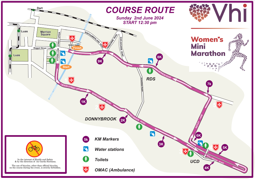
Vhi Womens Mini Marathon

WAVE ENTRY ROUTES

There are different entry routes, depending on what colour wave you’re in, and there are baggage drop areas available at three locations.

WHITE and PINK waves will enter through the junction of Pembroke Street Upper/Leeson Street Lower.

Baggage drop will be after this entrance point on Fitzwilliam Square.

Please make sure you are in your zone before 11.30am

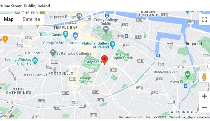
BLUE will enter through the junction of Hume Street/Stephen Green.

Baggage drop will be after this entrance point on Baggot Street.

Please make sure you are in your zone before 11.30am.

GREEN will enter through the junction of Hume Street/Stephen Green.

Baggage drop will be after this entrance point on Baggot Street.

Please make sure you are in your zone before 11.30M.

YELLOW will enter through the junction of Merrion Square West/Merrion Street Lower.

Baggage drop will be after this entrance point on Merrion Square West.

Please make sure you are in your zone before 12.00pm.

route map mini marathon 2024 Dublin


Travel and Road Options

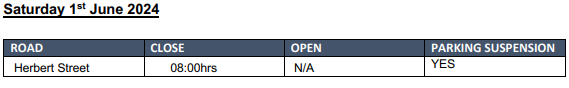
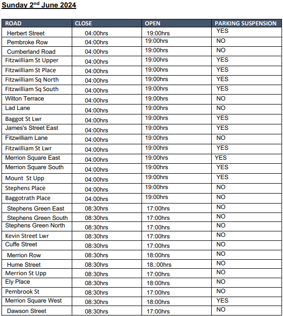
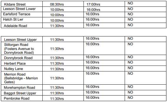
Temporary Road Closures (Sunday 2nd June 2024)

On Sunday 2nd June 2024, The Vhi Women’s Mini Marathon will be taking place which will require temporary road closures.

To ensure the safety of all participants and spectators, certain roads along the 10k route will be closed off during the event.

We kindly ask that you plan your travel accordingly and take note of the affected areas to avoid any inconvenience. Your cooperation and understanding in this matter is greatly appreciated.

Check out Dublinbus.ie for diversions in place, coser to the event.

Use the TFI journey Planner / TFI Live App to plan your route.

Diversion include:

Route 4 & 7

  • (From 1000 to 1800 hrs)
  • Northbound:
    • Normal route to Rock Road then divert right at Merrion gates onto Strand road, Beach Road, Church Avenue, Irishtown Road, Ringsend Road to Pearse Street, Westmorland Street back to normal route
  • Southbound:
    • Normal route to D’Olier Street then divert left to Townsend Street, Sandwith Street Lower left to Pearse Street, Ringsend Road, Irishtown Road, Church Avenue, Beach Road, Strand road, Merrion Gates turn left to Rock Road to normal route.

Route 11

  • (From 1000hrs to 1600hrs)
  • Northbound:
    • Normal route to Ranelagh Village then divert to Ranelagh Road, Charlemont Street, Camden Street lower Wexford Street, Aungier Street, Georges Street, Dame Street to normal route.
  • Southbound:
    • Normal route O Connell Street divert via Dame street, Georges Street, Aungier Street, Charlotte Way, Charlemont Street to Ranelagh Road and normal route.

Routes 15a/b & 26

  • (From first bus to 1900hrs)
    • All Buses to terminate at Pearse Street (opposite Trinity Capital Hotel)
  • Inbound:
    • Normal route to Townsend Street then divert right to Shaw Street to Pearse Street to terminate at stop #400.
  • Outbound:
    • Depart from Pearse Street right to Westmoreland Street to normal route.

Route 26

  • Inbound:
    • Normal route to D’Olier Street divert left to Townsend Street right to Shaw Street Right to Pearse Street to terminate at stop #400.
  • Outbound:
    • Depart from Pearse Street right to Westmoreland Street to normal route.

Route 37, 38/a, 39/a

  • (From first bus until 1000hrs due to closure of Baggot Street)
  • Northbound:
    • Normal route from terminus then divert to Haddington Road, Northumberland Road, Mount Street, Merrion Square North, Clare Street to Lincoln Place and normal route.
    • (39a divert from Waterloo Road to Pembroke Road to Northumberland Road and above diversion)
  • Southbound:
    • Normal route to Nassau Street and divert straight to South Leinster Street, Lincoln Place, Merrion Square North, Mount Street, Northumberland Road, Pembroke Road, Waterloo Road and normal route.
    • (From 1000hrs to 1900hrs due to race course shut down)
    • The 37, 38/a, 39/a, will operate to D’Olier Street then divert Townsend Street, Shaw Street to terminate at Stop 7588 Pearse Street.

Route 40

  • (From 1000hrs to 1700 hrs)
  • To City:
    • Normal route to D’O Lier Street then divert to Townsend Street, Shaw Street to Pearse Street and terminate.
  • From City:
    • From Pearse Street to normal route.

Route 44

  • (From 1000hrs to 1700 hrs)
  • Southbound:
    • Normal route to D’O Lier Street then divert to College Street, Dame street, Georges Street, Aungier Street, Charlotte Way, Charlemont Street and normal route.
  • Northbound
    • Normal route to Charlemont Street, divert via Camden Street, Aungier Street, Georges Street, Dame Street to normal route.

Route 46a  

  • (From 1000 to 1700)
  • Northbound:
    • Normal route to Stillorgan Road, right onto Mount Merrion Ave, left onto Rock Road, right at Merrion Gates onto Strand Road, Beach Road, Church Avenue, Irishtown Road and Ringsend Road to Pearse Street and normal route.
  • Southbound:
    • Normal route to D’Olier Street then divert left to Townsend Street, Sandwith Street Lower left to Pearse Street, Ringsend Road, Irishtown Road, Church Avenue, Beach Road, Strand Road, Merrion Gates turn left to Rock Road, right onto Mount Merrion Avenue and back to normal route at Stillorgan Road.

Buses using Foster’s Avenue will travel as follows: 

  • Northbound:
    • Normal route to Stillorgan Road then divert via Fosters Ave, Roebuck Road, right to Clonskeagh Road, Ranelagh Road, Charlemont Street, Camden Street, Aungier Street, George’s Street, Dame Street to normal route.
  • Southbound:
    • Normal route to D’Olier Street then divert via Dame Street, George’s Street, Aungier Street, Harcourt Road, Charlemont Street, Ranelagh Road, Clonskeagh Road, left to Roebuck Road, Fosters Avenue and right to Stillorgan Road and normal route.

Route 47

  • (1000hrs to 1700hrs)
  •  Northbound:
    • Normal route to Stillorgan Road then divert right to Mount Merrion Avenue, left to Rock Road then right at Merrion gates onto Strand road and normal route.
  • Southbound:
    • Normal route to Strand Road then divert straight to continue on Strand Road to Merrion Gates turn left to Rock Road right onto Mount Merrion Avenue and back to normal route at Stillorgan Road

Route 70

  • (From first bus until 1200 due to closure of Merrion Row)
  • Northbound:
    • Divert to Haddington Road, Northumberland Road, Mount Street, Merrion Square North, Clare Street, Lincoln Place and normal route.
  • Southbound:
    • Normal route to Nassau Street and divert straight to South Leinster Street, Lincoln Place, Merrion Square North, Mount Street, Northumberland Road, Pembroke Road, Waterloo Road and normal route.
  • From 1200hrs to 1900hrs the 70 will operate to D’Olier Street then divert Townsend Street, Shaw Street to Terminate at Stop 7588 Pearse Street Only

Route 145

  • (From 1000 to 1700)
  • Northbound:
    • Normal route to Stillorgan Road, Right onto Mount Merrion Ave, left onto Rock Road, Right at Merrion Gates onto Strand Road, Beach Road, Church Avenue, Irishtown Road and Ringsend Road to Pearse Street and normal route
  • Southbound:
    • Normal route to D’Olier Street then divert left to Townsend Street, Sandwith Street Lower left to Pearse Street, Ringsend Road, Irishtown Road, Church Avenue, Beach Road, Strand Road, Merrion Gates turn left to Rock Road, right onto Mount Merrion Avenue and back to normal route at Stillorgan Road.

Note: Buses using Foster’s Avenue will travel as follows:

  • Northbound:
    • Normal route to Stillorgan Road then divert via Fosters Ave, Roebuck Road, right to Clonskeagh Road, Ranelagh Road, Charlemont Street, Camden Street, Aungier Street, George’s Street, Dame Street to normal route.
  • Southbound:
    • Normal route to D’Olier Street then divert via Dame Street, George’s Street, Aungier Street, Harcourt Road, Charlemont Street, Ranelagh Road, Clonskeagh Road, left to Roebuck Road, Fosters Avenue and right to Stillorgan Road and normal route.

Route 155

  • (From 1000 to1700)
  • Northbound:
    • Normal route to Stillorgan Road, Right onto Mount Merrion Ave, left onto Rock Road, Right at Merrion Gates onto Strand Road, Beach Road, Church Avenue, Irishtown Road and Ringsend Road to Pearse Street and normal route.
  • Southbound:
    • Normal route to D’Olier Street then divert left to Townsend Street, Sandwith Street Lower left to Pearse Street, Ringsend Road, Irishtown Road, Church Avenue, Beach Road, Strand Road, Merrion Gates turn left to Rock Road, right onto Mount Merrion Avenue and back to normal route at Stillorgan Road.

Buses using Foster’s Avenue will travel as follows:

  • Northbound:
    • Normal route to Stillorgan Road then divert via Fosters Ave, Roebuck Road, right to Clonskeagh Road, Ranelagh Road, Charlemont Street, Camden Street, Aungier Street, George’s Street, Dame Street to normal route.
  • Southbound:
    • Normal route to D’Olier Street then divert via Dame Street, George’s Street, Aungier Street, Harcourt Road, Charlemont Street, Ranelagh Road, Clonskeagh Road, left to Roebuck Road, Fosters Avenue and right to Stillorgan Road and normal route.

Route S2

  • From Heuston:
    • Normal route to Ranelagh then divert to Charlemont Street and Terminate at stop 2903.
  • To Heuston:
    • Depart Charlemont Street to Charlotte Way, Charlemont Street, Ranelagh to Charleston Road and normal route. 

CITY TOURS:

  • 0800 to 1700hrs
    • Normal route to Junction of Pearse Street/ Westland Row then divert to Pearse Street, College Street, Dame Street, High Street to normal route.

Check out Luas.ie for updates to Luas services Closest Luas stop is St. Stephen’s Green

Use the TFI journey Planner / TFI Live App to plan your route.

DART – Check out Irishrail.ie – Closest DART stop is Pearse St Station

Use the TFI journey Planner / TFI Live App to plan your route.

BIKES – Check out DublinBikes.ie

CAR – There will be restricted car parking around Dublin City Centre. Bear in mind road closures will impact accessibility to the city on race day. Please check where your wave will be loading before deciding what car park to use.

  • Accessible parking for badge holders can be found here

COACH PARKING – Coach Parking drop-off location will be at Merrion Square North.

  • Please note that Merrion Square North is a drop-off location only, and this will be strictly enforced on the day.

  • Wilton Place will not be available for coach parking.

  • Parking will be available at NTA Coach Park on the day.